In this issue, we introduce the influence of ranging and related settings on coordinates and elevations.。The error produced by the distance to the coordinates is called the longitudinal error.。The slant distance is the total station measurement data.,Prism constant、Temperature and air pressure have an effect on slant range.;Horizontal distance and height difference are calculated data.,Scale factor、Horizontal correction has effect on horizontal distance;Balloon-air difference correction has influence on height difference。
Effect of prism constant on ranging
- Fixed error -
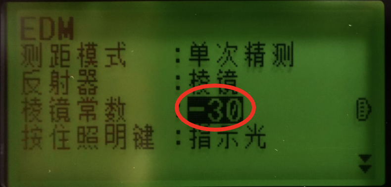
Setting up a station using a prism、Data acquisition、Lofting requires the correct prism constant to be entered。The deviation of the prism constant input problem in the measurement is a fixed deviation value.,And distance、It doesn't matter what the angle is.。If there is a fixed deviation in the measurement,Check whether the prism constant is input correctly.。Commonly used standard single prism,The prism constant is-30mm,Instrument default prism constant is 0。Prism constant is not input,Resulting in a measurement bias of-30mmLeft and right。
Effect of Temperature and Air Pressure on Ranging
- Scale error -
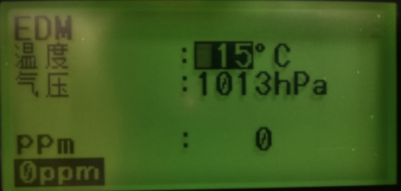
There is no deviation in the general ranging system of total station.,Ranging is affected by atmospheric refraction and the deviation is very small.,Negligible。Ranging is mainly affected by the outside temperature and air pressure.。When ranging in normal atmospheric environment,While the air pressure remains constant,,Every change in temperature 1℃,Or the temperature stays the same,Air pressure changes every 3.6hPa Time,Change per kilometer 1mm。 So,Meteorological parameters may not be set for routine measurement.,When making high precision distance measurement,The temperature and pressure of the atmosphere shall be determined using accurate measuring equipment,Enter the correct weather parameters,To apply a weather correction to the distance measurement,Instrument Default Weather CorrectionPPMIs 0,The condition is:The temperature is 15℃、The pressure is 1013hpa。The effect of temperature and air pressure on ranging is proportional error.,The farther the distance, the worse the error.。
Effect of Scale Factor on Ranging
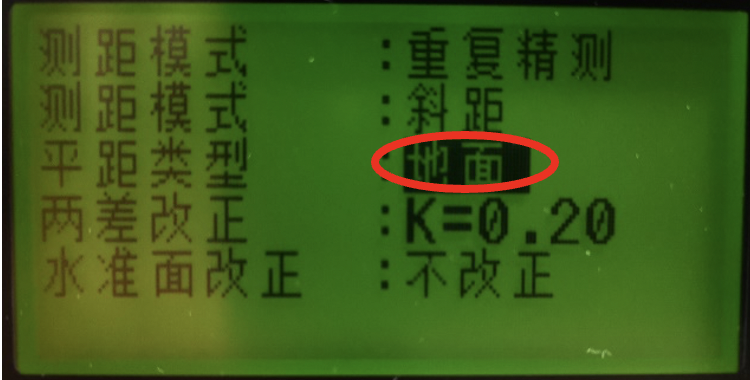
Horizontal distance types in total station setting include ground and plane.。The ground does not impose a scale factor,Planes impose a scale factor in the horizontal distance.;The scale factor changes only the calculated coordinate data,Do not change the measurement data,No effect on elevation。
1、Effect of Scale Factor on Coordinate Measurement
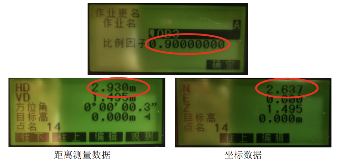
Measure any point on the total station measurement interfaceB,The horizontal distance from the total station to the point is 2.930m。At【 Set up 】-【Observation conditions】-【Distance】Medium,Change the horizontal distance type to【Plane】;At【 Memory 】-【Job renaming】Medium,Set the scale factor to 0.9。Hypothetical SiteAThe coordinates of the point are:N(X):0,E(Y):0,Z:0;In a coordinate measuring program, a pointBSet station for direction 0,After the station setting is completed;MeasureBThe coordinates of the point,BThe coordinates of the point areN;2.637,E:0,Z:1.495。Coordinates that are not changed by the scale factor should be:N;2.930,E:0,Z:1.495。Horizontal distance 2.930×0.9=2.637,It can be seen from the coordinates that the scale factor changes the coordinates.。So when the scale factor is applied,Calculate the horizontal distance of the coordinate=Measured horizontal distance×Scale factor。It follows from the formula that,When the scale factor is greater than 1,The calculated coordinate is greater than the actual coordinate;When the scale factor is less than 1,The calculated coordinate is smaller than the actual coordinate。When the coordinate measurement deviation is large,Check if it is a scale factor problem。
2、Influence of Scale Factor on Coordinate Lofting
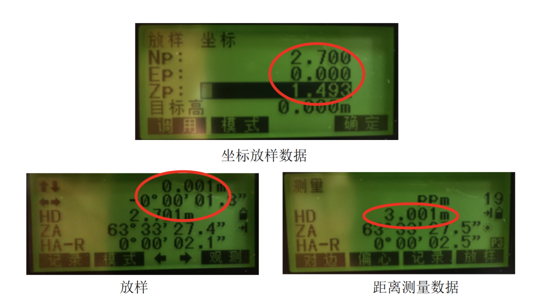
Influence of Scale Factor on Coordinate Lofting,The scale factor is also taken as 0..9。Hypothetical SiteAThe coordinates areN(X):0,E(Y):0,Z:0;Setting-out pointBThe coordinates are:N;2.70,E:0,Z:1.493。In Coordinate Loft,Set the station in azimuth mode.,Station complete,Conduct coordinate lofting。It can be seen from the setting out interface that the calculated value of the horizontal distance from the survey station to the setting out is 2.7m。Set the point position to the deviation of 1 according to the prompt on the instrument interface㎜。The distance from the total station to the point measured on the common interface is 3.001m。
So we can draw a conclusion from the data.:Actual setting out distance=Calculated horizontal distance/Scale factor。
3、How to Set the Scale Factor Correctly
It can be seen from the above introduction that,Scale factor has a great influence on coordinate measurement and coordinate lofting.。The reason for the change in the scale factor: 1.Artificial modification 2.Resection:Horizontal distance type is set to【Plane】,After resection is adopted for station setting,The scale factor changes.。Procedure for correct setting after scale factor Chan:At【 Memory 】-【Job renaming】Change the scale factor to 1 in;At【Observation conditions】-【Distance】Medium,Change the horizontal distance type to ground。When there is a scale factor in the coordinate system, it is set according to the use requirements.。
Level correction/Haiping correction
Level correction is to correct the horizontal distance.,Affect the plane coordinates,No effect on elevation。IM It has the function of converting slant distance into horizontal distance.,However, the elevation factor is not considered in the reduction.。When surveying at high altitudes,Leveling correction is recommended.,The spherical distance is calculated as follow:

In the formula:R Is the radius of curvature of the ellipsoid(6371000.000m)
H Is the average elevation of the station and the target point (The average elevation is automatically calculated according to the elevation of the observation station and the elevation of the target point)
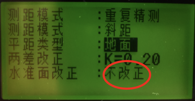
Level correction is also a proportional error.,The farther the distance,The greater the error。Normally set to no correction。
The Influence of the Balloon Difference on the Elevation Survey
The elevation is calculated from the difference in elevation between the two points.,Elevation difference except vertical angle,Also suffer from poor ball gas(Two differences)The impact of。Assume that the correction of the spherical air difference isf,Then: f=D2/2R×(1-K)
R-Radius of the Earth,Take 6371KM
KRefractive index(0.14/0.20)
The following table is:KTake 0.14,The correction value of spherical air difference to height difference at different distances
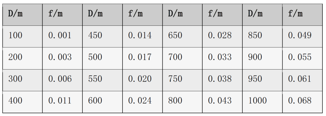
It can be seen from the table that the influence of the balloon difference varies with the distance.,The farther the distance, the larger the correction value.。At 100 meters,The correction value is 1.㎜;The 500m correction is 1..7cm.If the distance is far, the correction value of the two differences will have a greater impact.。When carrying out precise elevation survey,Set two-difference correction according to the use requirement。
Summing up
Deviation in measurement,Distance measurement and relevant settings shall be considered for large longitudinal deviation,Angle measurement error is considered in case of lateral deviation。The steps for analyzing the occurrence of deviation are as follow。
Eliminate gross errors
When there is a big error in the plane coordinate,Check whether the coordinates are input incorrectly、XAndYWhether the coordinate input is reversed、Whether the coordinate system of the control point is used incorrectly、Control point coordinates or whether the control point is used incorrectly。
Fixed error
Fixed deviation of coordinate or distance measurement,Check whether the prism constant is input incorrectly。
Calculate the data error
The horizontal distance and coordinate measured by the common interface are inconsistent with the coordinate measurement interface.,Check that the grid factor is 1,Is the horizontal distance type ground?;Whether the horizontal plane correction is set as no correction。The error of station setting is very small.,The viewpoint deviation is very large after lofting,Check horizontal offset type and scale factor。
Longitudinal scale error in coordinates
Check whether the temperature and air pressure are set according to the site conditions.;Whether the unit is set correctly。
Lateral scale error in coordinate
Check that the compensator is set to correctHV、Is the collimation error set to correct,Check 2CWhether the limit is exceeded、Alignment error、Target eccentricity。
The elevation deviation is large
Check if the collimation error is set to correct、Whether the index difference exceeds the limit,Is it necessary to apply a balloon correction?。If there is any deviation after both items are checked,Use a level to measure the height difference between two points,If the height difference deviation measured by the total station and the level is within the allowable error range,There is a problem with the control point.。
Contribution:Suojia Product Technology Department fyf


